
Caroline Gilmore
Orienteering is a competitive international sport in which participants find their way to various flagged checkpoints (controls) located along diverse and often unfamiliar terrain with the aid of a map and compass. The winner of the competition is the person/team who successfully locates all the controls in the correct sequence in the lowest elapsed time.
All ages and skill levels are welcome, and people can participate alone or in groups. Many participants do not run competitively at orienteering events, but rather use the opportunity to enjoy a slow guided map hike in the woods.
Orienteering can provide a combination of mental problem solving and physical challenge. The basic equipment required is compass, whistle, map and appropriate outdoor clothing for a walk in the woods.
My first exposure to orienteering was in the early1970s, when I participated in an orienteering exercise at Quantico with some girls from my Northern Virginia Girl Scout troop. I don’t remember too much about the day other than we got lost in the woods and the Marines were gathering a search party to send out to find us when we finally found our way back to the start point just before dusk.
Founded in 1978, Backwoods Orienteering Klub (BOK; www.backwoodsok.org) sponsors orienteering events and teaches orienteering in the North Carolina (NC) Piedmont. They hold several member-only and open (public) events each month, year round. At each open event, BOK offers a beginners class and sets up beginning, intermediate, advanced and expert courses. The cost of competing in a BOK open event is $5 per entry (a group counts as one entry; one course map included), plus $5 for rental of one electronic timing device (a “fingerstick”) for each entry. Extra maps cost $2 each.
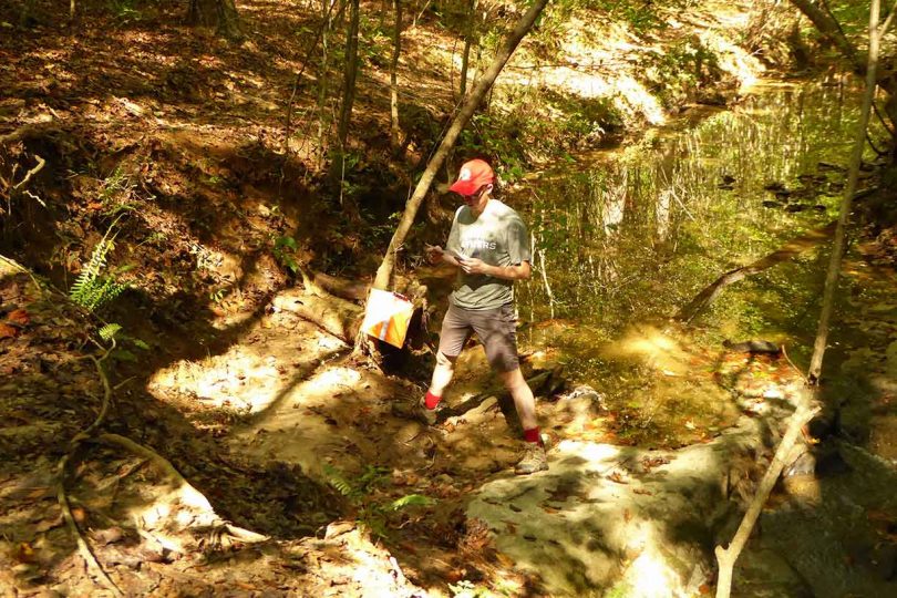
More recently, I competed in a BOK open orienteering event with Martin Smith of Pittsboro and his adult son, Jeremy Smith of Raleigh, at Umstead State Park North (entrance off of Highway 70) in Raleigh in October 2017. An expert orienteer led one of the largest ever BOK beginners’ classes, which included 40 Junior Reserve Officers’ Training Corps (JROTC) cadets from Danville, VA, and several local Boy Scouts.
The class covered the basics of the sport, as well as the fundamentals of map reading and compass use. BOK set up six courses, each with varying degrees of overall difficulty, ranging from the White Course (2.0 km in length, 10 controls), to the Red Course (7.1 km, 14 controls). A total of 103 teams started the competition; 86 teams completed their assigned courses and 17 teams did not finish.
My friends and I started the Yellow Course (2.6 km, 11 controls) along with 25 other teams. We got off track a couple of times, which slowed us down a bit, but were able to successfully locate all 11 controls in the correct sequence and maneuver our way to the finish line. Of the 25 teams that started, 20 completed the Yellow Course and five did not finish it. We finished in twelfth place, with a time of 57:01. Overall Yellow Course finish times ranged from 26:09 to 1:26:59.

Jeremy Smith checks in at an orienteering control using a fingerstick electronic timing device. PHOTO BY CAROLINE GILMORE
In February 2018, I competed in a second BOK open event with Smith at the Fews Ford Access at Eno River State Park in Durham. This was BOK’s first open event at the ERSP. The six set courses ranged in difficulty from Beginner White (1.9 km in length, 11 controls) to Expert Red (6.3 km, 8 controls). Sixty-four teams started the competition, including four teams from Boy Scout Troop 334 in Raleigh; three teams DNF.
We did the Yellow course (2.7 km, 11 controls), and although the course controls were not located in obvious places, they could be found fairly readily. We didn’t get lost or backtrack once on the course and came in third place out of seven teams, with a finish time of 54:26. Overall Yellow Course finish times ranged from 19:42 to 2:05:47. I was able to finally figure out how to use the compass with the map to set and follow a course of direction in the woods, and my navigating skills confidence has soared!
After my second orienteering competition, I spoke with the event’s director, Dave Waller of Chapel Hill, who has been orienteering for 20 years and currently directs and sets many BOK orienteering events annually. He relayed that “the big attraction [to the sport] is two-fold: 1) It gives you a closer connection with nature” and you literally “understand your place in the world” and 2) It is a “combination between a mental and a physical challenge” and there is “always a dynamic between the mental and physical aspects of the sport.” He also noted that “people who like to problem solve and think would be attracted to the sport.”
The next BOK open orienteering event will be held at 12 noon Sunday, April 8, at Carolina North Forest in Chapel Hill. Maybe I will see you there. Happy orienteering!
Orienteering Course Descriptions
A standard orienteering course consists of a start, a series of control sites that are marked by circles, connected by lines and numbered in the order they are to be visited, and a finish.
Competitors are given a “control description sheet” or “clue sheet” which consists of a detailed color topographical map, a legend and a key and gives a precise description of the feature and the location of the controls on the course.
Out in the terrain, a control flag marks the location that the orienteer must visit. Competitors use the map and a compass to set a course from one control point to the next in the correct sequence. Each competitor carries a paper or electronic control card which is punched or electronically monitored; the control card or electronic fingerstick are checked at the start and finish of the course run. At each control point, participants must “punch in” in the correct order.
Most events now use electronic “punching” (using a “finger stick” with an electronic chip inside it that records a competitor’s time at each control they visit) instead of paper punching, although cards and needle punches are still widely used.
An overall description of the different levels of orienteering courses is provided in the table below.
